KALGARD
SYSTEMS
Advanced AerialNavigation System
KALGARD Systems delivers cutting-edge autonomous navigation technology that enables UAVs to operate with 5-10m error in GPS-denied environments through advanced computer vision and sensor fusion.
MerlinSight Navigation Module
Real-Time GPS-Denied Navigation
About KALGARD Systems
We are a defense and aerospace focused software and hardware manufacturer delivering state-of-the-art autonomous navigation solutions for unmanned aerial vehicles. Leveraging bespoke advanced computer-vision algorithms and robust sensor-fusion architectures, our systems empower UAVs to operate with pinpoint accuracy even in GPS-denied environments. Founded by an Imperial College London engineer with a lifelong passion for drones, we combine academic rigor with practical innovation to redefine what aerial autonomy can achieve.
Precision
Meter-accurate navigation systems for critical applications
Vision
Advanced computer vision algorithms for real-time navigation
Innovation
Cutting-edge technology pushing the boundaries of what's possible
Reliability
Mission-critical systems built for consistent performance
Our Story
Founded with a vision to solve the critical challenge of autonomous navigation in GPS-denied environments, KALGARD Systems emerged from years of research in satellite image matching and multi-sensor fusion technologies.
Our proprietary visual-satellite positioning system combines real-time aerial footage analysis with high-resolution reference imagery, enabling 5-10m error positioning accuracy where traditional GPS systems fail.
We hope that soon our navigation solutions will serve search and rescue operations, infrastructure inspection, agricultural surveying, and security missions worldwide.
Our Mission
To enable the next generation of autonomous drones through advanced visual navigation technology, making autonomous flight safer, more reliable, and accessible to industries worldwide.
Our Products
Our Advanced Aerial Navigation System - a comprehensive solution combining visual-satellite positioning, multi-sensor fusion, and real-time processing for autonomous UAV operations.
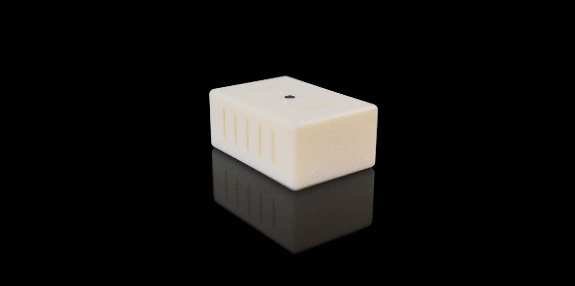
MerlinSight
Navigation System
MerlinSight Navigation System
Our comprehensive navigation solution combines proprietary satellite image matching technology with advanced sensor fusion, enabling autonomous UAV operations in GPS-denied environments with 5-10m error positioning accuracy.
Visual-Satellite Positioning
5-10m error accuracy GPS-free
Multi-Sensor Fusion
Extended Kalman Filter
Real-Time Processing
20Hz position updates
Soon Enterprise Ready
Professional ground station
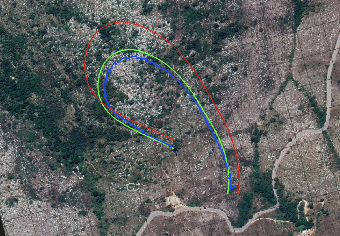
Drift Correction
Visual-Satellite Positioning
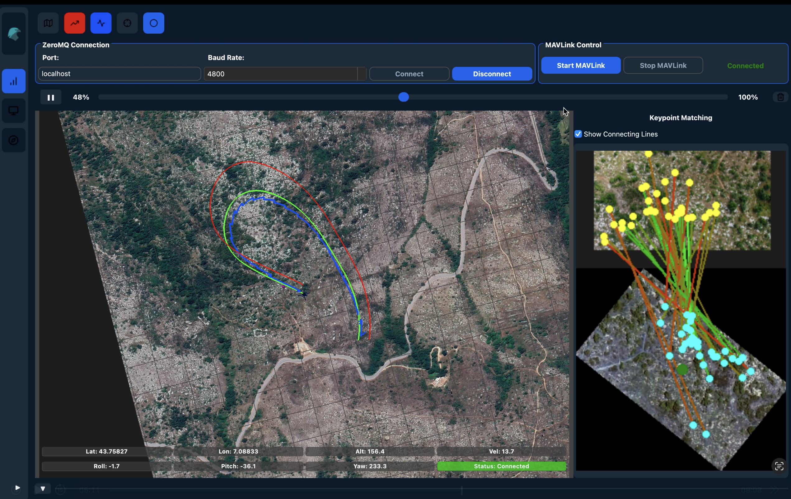
Drift Correction Technology
Our proprietary visual-satellite positioning technology continuously corrects positioning drift by comparing live aerial imagery with reference satellite data, ensuring 5-10m error accuracy even in GPS-denied environments.
Red Line - Dead Reckoning
Traditional inertial navigation that accumulates positioning errors over time, causing significant drift from the true path.
Green Line - Reference GPS
Ground truth reference path showing the actual flight trajectory for comparison and validation purposes.
Blue Line - MerlinSight Output
Our corrected positioning solution that maintains 5-10m error accuracy by continuously applying visual-satellite drift correction.
Key Insight: The blue line demonstrates how our technology eliminates the cumulative drift errors that plague traditional navigation systems, providing reliable positioning even when GPS signals are unavailable or unreliable.
Next: Autonomous Drones
Building on our advanced navigation technology, our next step is developing fully autonomous drones. These complete UAV systems will integrate our MerlinSight navigation with intelligent flight control, enabling unprecedented autonomous operations in complex environments.
(coming soon)
(coming soon)
Advanced Computer Vision Technology
See our proprietary visual-satellite positioning algorithms in action, delivering 5-10m error accuracy through real-time image matching and keypoint detection.
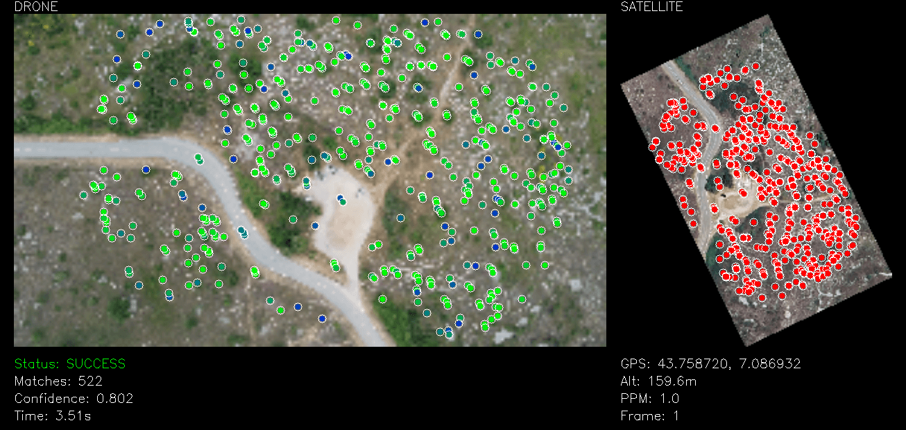
Keypoint Matching
Our advanced computer vision algorithms identify and match distinctive features between live aerial footage and reference satellite imagery, enabling precise positioning without GPS.
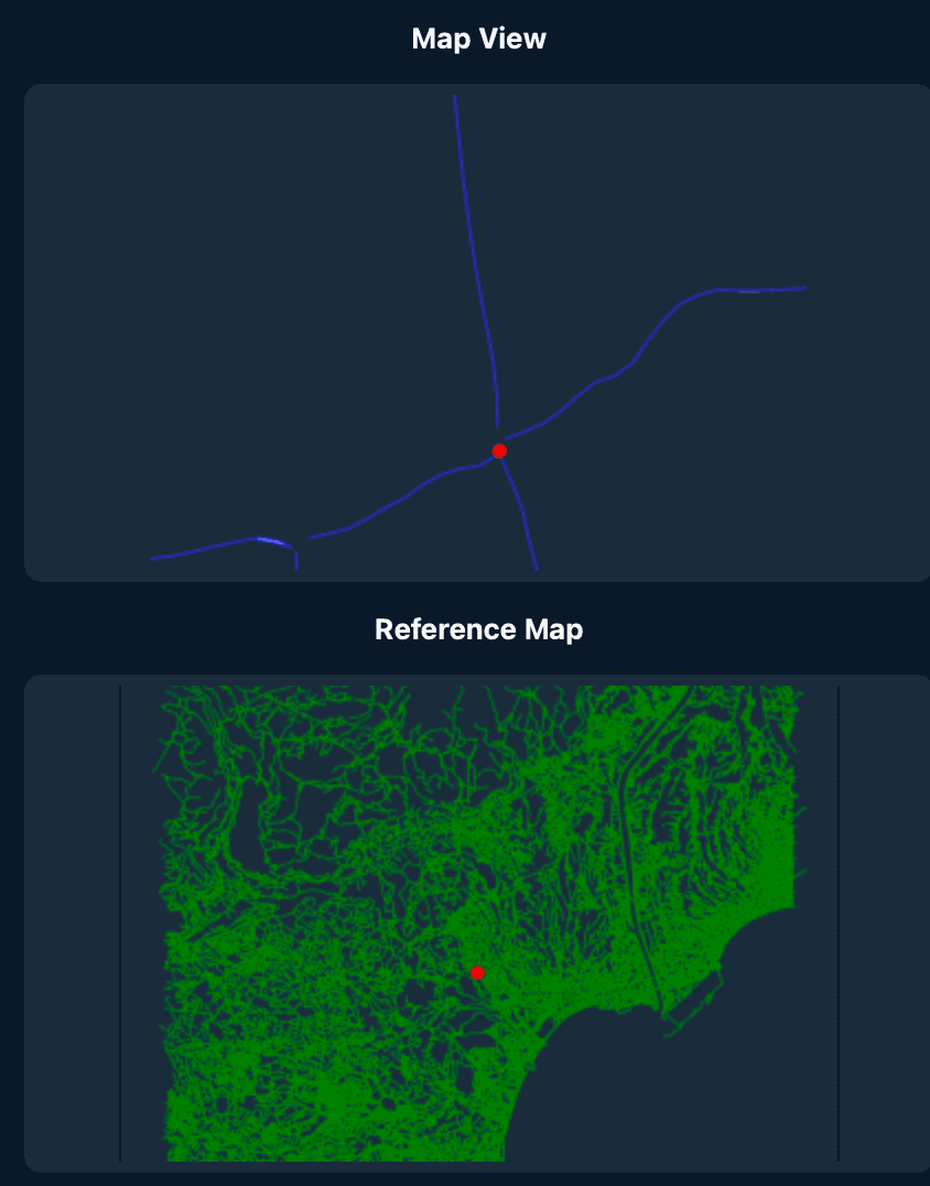
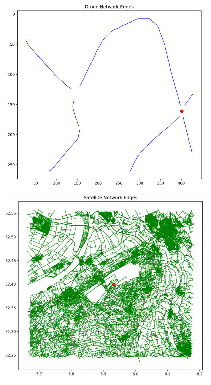
Road Graph Matching
Intelligent road network analysis and matching capabilities enhance navigation accuracy by correlating detected road patterns with known infrastructure data for robust positioning.
See MerlinSight in Action
Watch our autonomous navigation system in real-world flight operations, demonstrating GPS-denied positioning capabilities in challenging environments.
Advanced Features
Our Advanced Aerial Navigation System combines proprietary visual-satellite positioning with multi-sensor fusion technology to deliver enterprise-grade autonomous navigation capabilities.
Visual-Satellite Positioning
Proprietary satellite image matching technology compares live aerial footage with reference imagery for 5-10m error positioning accuracy.
Real-Time Processing
High-frequency position updates up to 20Hz with trajectory replay algorithms for handling processing delays.
Multi-Sensor Fusion
Advanced Extended Kalman Filter fuses our computer vision absolute positioning features, VIO, and barometric altitude with automatic redundancy.
Professional Ground Station
Comprehensive monitoring dashboard with live flight visualization, telemetry display, and mission planning capabilities.
Intelligent Mapping
Automated road and landmark detection with building recognition for enhanced navigation reference and obstacle avoidance.
Enterprise Architecture
Modular design with robust error handling, comprehensive logging, and Docker containerization for scalable deployment.
Technical Specifications
Built with enterprise-grade components and tested in the most demanding conditions.
Professional Ground Station
Comprehensive monitoring interface with real-time telemetry and drift correction
Get In Touch
Ready to enable GPS-denied autonomous operations? Contact us to learn more about our Advanced Aerial Navigation System and how it can enhance your UAV mission capabilities.